


Major Projects
Landslide Hazard Zonation Mapping.
Implementing Resettlement of Landslide Victims.
Construction of Precast Houses for Landslide & Flood Affected People.
Landslide Risk Mapping Project.
R & D Program.
Training & Awareness.
Precast Housing Construction in North & East for conflict affected people.
NGI Technical Collaboration.
Drone Survey (Consultancies).
Building code Development.
Introduction
National Building Research Organisation (NBRO) receives requests from developers for their building construction activities through Urban Development Authority (UDA), Department of Coast Conservation and Coastal Resource Management (CCD) and Sri Lanka Tourism Development Authority (SLTDA) for obtaining NBRO building clearance. Before granting their approval, these authorities request NBRO to assess impacts of a particular proposed development to adjacent properties and surrounding environment. The number of such requests to NBRO has increased after the Urban Development Authority’s recent withdrawal of powers of local authorities for the approval of such buildings and the recent incidents of building collapses and related issues. This report includes the general scope of work for the reviewing process and the guidelines for the Engineering consultancy fees that has to be paid by the developers for obtaining the clearance from NBRO.
The clearance of NBRO is a written statement issued to a client who submits a duly completed application to NBRO, indicating that:
- The developer has identified all the geological and geotechnical hazards and constraints present on the site
- The developer has evaluated those hazards and constraints, which would affect the proposed development of the site or impact on surrounding structures
- The developer has proposed appropriate measures to avoid and/or mitigate these hazards and constraints
- Geotechnical clearance does not and shall not be construed as constituting an approval or entitlement of any form or type.
Flow chart for the clearance process is indicated in Figure 1. Approximately the reviewing process will take about 2 weeks after the submission of all the required documents as explained in Table 1.
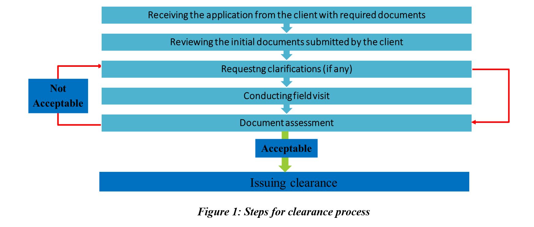
Table 1: Scope of work for the reviewing process
|
No |
Reviewing items |
Scope of work for reviewing Process of the items |
|
1 |
UDA/ SLTDA/ CCD letter requesting NBRO’s Approval. |
Reviewing whether the UDA/ SLTDA/ CCD letter contains the request for obtaining NBRO’s approval. |
|
2 |
Architectural Drawings. |
Reviewing the basic details like floor areas, plan views and the requirements of NBRO for certified details of the drawings. |
|
3 |
Report on Geological and Geotechnical investigation together with basic recommendations for foundations and other aspects. Adequate number of boreholes should have been done with necessary in situ tests and laboratory tests to establish the necessary design parameters. |
Reviewing the recommendations of the geo technical investigation report and checking whether foundation type satisfies the soil conditions and bearing capacity values. Checking the process of obtaining the allowable bearing capacity values using the bore hole details and the Uniaxial Compressive Strength (UCS) of rock cores. |
|
4 |
A survey of the current state (cracks or any form of distress) in the properties in the vicinity (Pre-construction condition survey report). |
Reviewing whether the crack survey has been conducted according to the requirements of NBRO.
|
|
5 |
A detailed design report on excavation support system |
Reviewing whether the excavation support system satisfy the relevant standards and provide necessary safety margins against any failure of the system and whether it describe Stresses, bending moments etc. and deformations of the system. |
|
6 |
A detailed design report on foundation. |
Reviewing whether the foundation design satisfy the recommendations of the geo technical investigation and checking whether the foundation design satisfy the required end bearing capacities, skin frictions and capability of bearing column loads. |
|
7 |
A detailed report on construction method statements |
Reviewing whether the submitted method statements satisfy the relevant standards and provide necessary safety margins against failure of the systems according to the given recommendations in the geotechnical report. |
|
8 |
Contingency plan with method statement to rectify any excessive deformations in the excavation support system or other important properties in the vicinity. |
Reviewing whether the submitted Contingency plan does satisfy the rectifying process of any excessive deformations in the excavation support system or any other properties in the vicinity. |
Rate breakdown for reviewing the documents for commercial development projects,
Generally, apart from a special site condition, UDA, SLTDA and CCD requesting NBRO building clearance for developments which have a gross floor area more than 4000 square feet (375m2). Therefore, initial rate breakdown has been calculated based on 375 m2.
For initial 375 m2 = LKR 70, 000.00
For every excess 300 m2 = LKR 1500.00
Rate breakdown for reviewing the documents for residential development projects,
Considering the amount of applications received and the workload for reviewing the documents in a residential development projects, following rate breakdown will be used for reviewing residential projects.
For initial 375 m2 = LKR 35, 000.00
For every excess 300 m2 = LKR 750.00
In addition to the above amounts, following application processing fee and clearance renewal fees have to be paid by the developer.
Application Fee,
For commercial development projects = Rs.2500.00
For residential development projects = Rs.5000.00
Clearance Renewal Fee,
The above fee scale will be only for a single assessment. However, if further review, reassessment, verification or renewal is required, developer has to pay the followings fees,
For commercial development projects = Rs.14, 000.00
For residential development projects = Rs.7000.00
- Name of the unit: Proposed unit will be referred to as “Building Clearance Processing Unit”.
- Scope of work: This unit will address issues pertaining to (i) high-rise buildings (Over G+4 floors) (ii) buildings with floor area more than 4000 sq. ft. and (iii) any other buildings and structures needing excavations that can impact on adjacent buildings and structures.
- Area coverage: The unit will process the clearance requests of the building type mentioned above all over Sri Lanka.
- Reporting method: Clearance will be issued after the assessment carried out on possible impacts of proposed development on adjacent properties and surrounding environment based on the field investigations and review of the documents submitted by the developer.
- Main tasks of this unit:
- Conducting field visits
- Reviewing the necessary investigation reports and providing recommendations
- Preparing a guideline for the building approval process
- Issuing the clearance
- Investigation procedure: An expert team of the unit, based on their expertise, will generate the individual reports for each building after conducting necessary investigations on the following:
- Geotechnical investigations
- Structural stability
- Disaster Susceptibility
- Structure of the BCPU: (i) All the activities of the BCPU will be coordinated by Human Settlement Planning and Training Division (HSPTD) of NBRO and final clearance of the NBRO will be issued with the signature of the Director HSPTD of the NBRO based on the recommendations provided by respective directors of NBRO’s technical divisions. (ii) The unit will have staffs consisting of a combination of professionals at NBRO, who are experts in geotechnical engineering, geologists, structural engineering, civil engineering, environmental engineering, resilient construction, and human settlement planning (as indicated by the table below). (iii) Above experts will be assigned to respective divisions and will provide their recommendations through directors of their divisions to Director, HSPTD. (iv) BCPU will also seek the advice of external consultants considering the magnitude and risk of the project with the prior approval of Director General.
- Transport fee will be charged based on the distance to the proposed development from NBRO as per the NBRO’s transport charges.
- Following expert team will involve in the document reviewing process,
- Senior Geotechnical Engineer
- Town Planner/ Coordinator of BCPU
- Civil/Geotechnical Engineers
- Structural Engineers
- Geologists
- Environmental Engineer
- MA Technical
In addition to the above expert team, considering about the complexity of the development project, NBRO will seek relevant professional experts from a professional institute for reviewing the needed documents.
Background
This research focus on technical and community based approaches to identify the inundation locations and their physical properties based on riverine and flash floods scenarios, to initiate the proper flood hazard assessment in the municipality area of Ratnapura.
In recent decades, Ratnapura Municipality area (RMC) experienced number of flooding events. The catastrophic flood that occurred in May 2003 resulted many deaths and loss of properties in Municipality area and there are 17 major flood incidents have been occurred.So in order to response to such event in advance and flood hazard elsewhere in the locality, there is need to develop detailed flood information profile.
The project
The preliminary task was focused on identification of low lying areas using Arc GIS based model in order to get reliable inundation locations and estimation of riverine flooding extent and inundation depth. (1) First a GIS based terrain analysis was employed using contour, spot height, and stream network enforced Topo raster (Digital Elevation Model) along with set of raster analysis tools, to derive the extent of possible flooding based on the flood level from the surface level of river. . (2) Second, an integrated hydrological concept based model (Blue Spot model) was employed. It help to identify the low lying locations which has higher possibility to fill up and overflow due to the heavy rainfall. Also it estimate the volume of sinks and amount of rain fall that requires to fill each sink. (3) Community based participatory approach was used to collect information on year and monthly frequency of flood, extent of inundation, flood depths and location of evacuation center. The result of the each method was revealed through series of detailed maps (as GIS layers) and summarized table, that showing the location of low lying areas in terms of derived depths ,water level from the river surface and amount of required rainfall to fill each identified depression location. In addition, possible flow paths, catchment boundaries also derived.
Findings
Out puts from terrain analysis
spatial extent of the flooding derived at each 0.5m increment of water level based on river surface level (17m) up to 24m, all this extents are visualize by series of following maps (fig.2, fig.3) at MC and GN level.
Results shows that if the water level would increase up to 7m (considered maximum level), then almost 30 percentage of the MC will be inundated. It would cause damages to 3300 buildings. (Table 1)
Output from blue spot model
Model identified the spatial locations of sink points which could be inundated due to the flash flood, further regarded average amount of rainfall values for those low lying area also derived. Almost 90% identified low lying area would be inundated by 20 - 150 mm of rainfall (hourly) range. Statistics shows that 15 % of the MC prone to torrential rain fall flooding. If the rainfall exceed the 150mm of average, it would inundated 360 hectares of the area. (Table 2)
Output from community based participatory approach
Inundation locations were classified through the average depths from the respective terrain area that obtained through the workshops. Area situated along the left bank of Kālu River and almost 90% of the paddy cultivation mostly affect by riverine flooding. Depths of the flood vary from minimum 2 foot to more than 10 foot, almost all the identified flooding locations are within the range of 17m – 23m. As per the outcome of community consultation, the extent of the flood hazard is up to 480 hectares. It means, 20 percent of the MC area has prone to annual flooding. Among that 90 % of the area getting more than 6 foot of flood level.Due to this flood extent, it has estimated that, 1500 buildings are vulnerable to flood inundation. Table 3 shows profile of elements at risk.
Introduction
Sri Lanka being a small island in the Indian Ocean at the path of two monsoons is mostly affected by weather related hazards. Floods mostly due to monsoonal rain or effects of low pressure systems and droughts due to failure of monsoonal rain are the most common hazards experienced in Sri Lanka. This country is also prone to hazards such as landslides, lightning strikes, coastal erosion, epidemics and effects of environmental pollution. In 2004, almost two-thirds of the Sri Lankan coast was affected by the Indian Ocean tsunami highlighting the country’s vulnerability to low-frequency but high impact events.
The figure 01 provides, information available on the people affected by natural disasters during the period 1974-2004. It clearly identifies Floods, Drought, Tsunami, Storm and Landslides as the most common natural disasters in the country.
Sri Lanka experienced different types of disasters in the last few decades and people lost their lives & properties in intolerable situation. Government and stream lined non-government organizations had provided disaster relief, rehabilitation and reconstruction activities in to certain level with financial support to overcome this situation up to certain extent.
Risk Transfer Past Practice
Disaster Relief, Rehabilitation and Reconstruction activities will be released directly to the Government Agents/District Secretaries by National Disaster Relief Services Centre (NDRSC) of the Ministry of Disaster Management, and action will be taken to dispatch a copy of same to the relevant Divisional Secretaries. Divisional Secretaries should obtain provisions allocated to their division from District Secretaries. The basic eligibility for entitlement to relief under widespread and casual disasters is that the monthly income of the family should be less than Rs.3000.00. The family includes mother, father, and all unmarried sons and daughters. If the parents have passed away, unmarried brothers and sisters. If the parents of the mother or the father are living with them, they too should be included. The total monthly income of the family is the aggregate income derived from all sources.
Risk Transfer Past Practice - Practical Situation
In May 2011 floods occurred in Kegalle, Gampaha, Colombo, and Galle Districts. As a result, 8,479 families consisting of 33,201 peoples were affected, 5 people dead, 6 injured, and 341 houses were affected including 71 fully damaged and 270 partially damaged. As a proactive approach Ministry of Disaster Management released allocation based on the information on disaster incidence reported. Rs. 463,738,830.15 have been released to the following disaster affected districts and Rs. 6,513,646.85 expended for the relief materials distribution for the flood victims during January - August 2011.
Housing subsidy was paid to repair or reconstruct residential house damaged by the disaster. This subsidy was paid only in instances where the monthly income of the applicant is Rs. 3,000.00 or less. Rs. 50,000.00 for a fully damaged house and Rs. 25,000.00 for partially damaged house was paid until May 2011, according to NDRSC circular No: 2007/10 dated 01/10/2007. 30,569 houses were rehabilitated / reconstructed in 2011 until May 2011 and Rs 53,045,194.00 have been paid for the same. With the implementation of the National Budget circular No 152, this activity was transferred to the Ministry of Economic Development with effect from 14/05/2011.
New Program for Risk Transfer - National Natural Disaster Insurance Policy
As a proposal of 2016 Budget, National Natural Disaster Insurance Policy Program had been introduced and implemented to provide disaster relief and subsidies to people who are affected due to the disaster. This program was introduced to improve the economy and development of the country. National Natural Disaster Insurance Policy is executed by joined collaboration of Ministry of Disaster Management and National Insurance Trust Fund, under the supervision of Ministry of Finance. Under this policy program identified Natural Disasters like Cyclones, Storm, Tempest, Flood, Landslide, Hurricane, Earthquake, Tsunami and any other similar natural perils, excluding Drought and man-made disasters will be covered under this insurance.
National Disaster Insurance Policy scope of Coverage
Under the National Natural Disaster Insurance Policy program, its benefits and coverages are as follows;
Natural Disaster Coverage
- Covers lives and properties, specifically all households and small business establishments (any business of which annual turnover does not exceed Rs. 10 million) covered up to Rs. 2.5 million in each respect of damages (per event) caused to their property and contents due to Cyclones, Storm, Tempest, Flood, Landslide, Hurricane, Earthquake, Tsunami and any other similar natural perils, excluding Drought and man-made disasters. Property damage for large businesses and those having insured with an insurance company are excluded.
- An accidental death cover for all victims of natural disasters will be paid Rs. 100,000 each under the Personal Accident Insurance Policy.
Emergency relief measures for victims of natural disasters
- Annual limit for emergency relief expenses will be Rs. 1.5 billion.
- For different types and scales of occurrences, there will be sub limits (Table 1) as follows;
Limits of Coverage
- Structural Damages to property and content in respect of households and small business establishments (Structural damages) - Annual limit of Rs. 8.5 billion
- Cost of emergency relief measures - Annual limit of Rs. 1.5 billion
- Total limit liability in aggregate for the period is Rs. 10 billion
National Natural Disaster Insurance Policy execution process
When any Natural Disaster reported in any of the district, according to disaster status report provided by the National Disaster Relief Services Center (NDRSC), Disaster Occurrence Report and estimated budget for disaster relief which is under recommendation of Divisional Secretariat and approval of District Secretariat, has to be reported to NDRSC.
Previously disaster relief services have been provided through allocated quota from general budget of Sri Lanka. Therefore, lot of difficulties face to provide relief services to victims due to delayed process and limited budget allocation.
With introducing this National Natural Disaster Insurance Policy Program, District Secretariat can apply for estimated budget for disaster relief services when disaster struck to their representative district, it can be received as an advance under the insurance policy of National Insurance Trust Fund from NDRSC. District Secretariat will allocate financial allocations among the Divisional Secretariats based on the gratitude of the disaster situation in each Divisional Secretariat Division.
Recent Disaster Situation in Sri Lanka
Floods and landslides caused in last May 2016 by torrential rains with gale force winds in Sri Lanka have left 71 people dead, 127 missing, and over 319,000 displaced from homes while over a 427,000 people are affected by the adverse weather.
According to the government assessments, 427,918 people belonging to 105,360 families are affected by floods and landslides as of the situation report issued by the Emergency Opera-ton Centre of DMC as of 20th May 2016. Out of the affected, 319,507 people from 64,308 families have been evacuated to 602 safe locations. About 474 houses are reported to be fully damaged and 3,674 houses partially damage by floods and landslides.
Case studies and NBRO role
Flood Damage Assessment - Kolonnawa DS Division
As a result of high monsoon rainfall, flash floods due to intense rainfall in the upper catchments, and cyclonic floods (due to development of low-pressure systems in the Bay of Bengal). Water levels of the Kelani River, as recorded at the Nagalagam Street river gauge, are shown in figure. When the water level, at this gauge (between 5.0 – 7.0 ft), a minor flood situation occurs, whereas when the level exceeds 7.0 ft a major flood situation takes place. Water level exceeding 9.0 ft, at this location is considered as a dangerous flood. Kolonnawa DS Division has been affected by dangerous floods in three occasions within the period from 1965 to 2011. According to the historical data the region has been affected by a flood in the year 1957 also. Kolonnawa DS Division area was stricken by another dangerous flood on May 18, 2016. As per the records from Kolonnawa Divisional Secretariat, 28,657 houses in 40 GN Divisions had been fully or partially damaged.
Based on the experience in the Landslide Damage Assessment in Aranayake and Yatiyanthota DS Divisions in Kegalle District, Ministry of Disaster Management had provided provisions to National Building Research Organisation to conduct flood damage assessment in Kolonnawa DS Division. Flood Damage Assessment in Kolonnawa is under progress. Further support to estimate damage on building NBRO developed post disaster housing damage recovery cost estimation guideline. To evaluate flood damage assessment for each affected building, survey form has been used by the NBRO Technical Officers.
Conclusion
As a country, Sri Lanka is expose for most of the natural disasters. Establishment of National Natural Disaster Insurance Policy is a way forward to recovery in economy and development of the country. This Insurance policy has to be implement with the establishment of monitoring system. Montoring should be done with the support of local governance and its benefits will be distributed among disaster victims in proper and correct proportion.
National Natural Disaster Insurance Policy’s validity period will be expired in end of the year 2016. This mechanism is better to continue in the country, though it will be increased relief, rehabilitation and reconstruction activities after a Disaster in proper mechanism.
Stream line to this National Natural Disaster Insurance Policy, post disaster construction sand development guidelines has to be developed to enhance “Built Back Better” develop-ment within the country.
A low pressure above Sri Lanka caused torrential rainfall all over the country from May 2016 onwards. It caused damages to 22 districts countrywide were affected by landslides and floods. Soon after this disaster situation, number of agencies came forward to provide financial assistance on relief for the flood and landslide victims. As a part of financial assistance from Asian Development Bank (ADB), Ministry of Disaster Management has decided to construct evacuation centres in Wattala, Badulla and Aranayake Divisional Secretariat areas. As a technical arm of the ministry of Disaster management, National Building Research Organization (NBRO) has been assign to construct these evacuation centres.
Aim of constructing these evacuation centres are to accommodate and look after the welfare of the landslide and flood victims for short period of time. Design specifications of the evacuation centre includes community hall to accommodate nearly 100 individuals, office room, store room, area for food preparation, wash room facilities, toilet facilities, space for children play area and parking space. Floor area of the evacuation centre is 6052Sq.ft. Location of the evacuation centres close proximity to town area and covering vast number of disaster victims is an important aspect considered in deciding location of these evacuation centres.
Torrential rainfall all over the country in May 2016 caused damages to 22 districts country wide due to landslides and floods. As the result of this disaster 168 families were displaced inKegalle district. Further, 1930 families have been evacuated to safer locations due to prevailing high landslide risk in the district. Government decided to resettle around 2000 families in order to treat the prevailing landslide risk. Resettlement of these families is in progress with the technical assistance of National Building Research Organization (NBRO). Estimated cost per housing unit is 1.2 Million LKR. Local and international donor agencies proving funds to deliver services at the resettlement process (Ex. Road improvements, construction of transitional shelters, construction of houses, etc.).
Large scale resettlement in Kegalle district is different experience for stakeholders involve in this process. As collective decision resettlement process, below components have been incorporated under Planning, Designing and Construction phases.
NBRO provides technical assistance during Designing and Construction phases as follows.
Designing
Land Selection
Land selection process is led by District Secretary with the technical guidance of NBRO. Suitability of the land for new settlements has been evaluated in terms of disaster risk, accessibility for physical and social infrastructure, environmental compatibility, and accessibility to livelihood opportunities and distance to former settlements.
Land Development
NBRO assess and grant approval for each blocking out plans. NBRO expert team inspect the site and evaluate applicability of the block out plans in terms of land subdivision regulations, storm water management and NBRO regulation on subdivisions in hilly areas. Land preparations (clearing of land, laying of road and drainage network, etc.) took place with the NBRO recommendations.
House Design
NBRO design house plans under the concept call “Disaster Resilient Housing Construction”. Three type plans have been designed by NBRO to meet relevant national and international standards, be culturally and climatically appropriate, durable and easy to maintain, allow for future adaptation and be developed in partnership with the intended occupants. These plans are specially designed incorporating disaster resilient features to withstand landslides, high wind and flood.
Construction
Construction Management
NBRO continuously monitor the quality of housing construction by providing necessary consultation ensuring its sustainability.
Workmanship
Series of training programmes on “Disaster resilient housing construction methodologies” were conducted by NBRO targeting the masons’, who involve in housing construction in the district. Aim of the training programme is to enhance construction skills of the individuals.
National Building Research Organisation (NBRO) operating under the vision of creating a safer built environment has extended its studies on disaster resilient construction. As its initial phase, the main focus of these studies was on housing sector after considering the frequency of natural disasters and severity of damages on houses caused by them. Now, NBRO recommends incorporating disaster resilient features into housing construction when sites are located in localities prone to disasters such as floods, landslides, high wind, and tsunami or in areas having expansive soil.
In this context, the Human Settlements Planning and Training Division of NBRO initiated a program to construct disaster resilient model houses in disaster prone areas with the consent of the Ministry of Disaster Management. In this project, disaster resilient features are showcased in hazard prone areas through model houses to enhance awareness within the community on disaster resilient construction.
Ultimate goal of this program was to promote the disaster resilient construction culture among disaster vulnerable communities and thereby to reduce potential damages on houses in the long run. As the next step of this project, NBRO published the “Hazard Resilient Housing Construction Manual”, and people who are interested in resilient construction can obtain a manual free of charge from NBRO head office.
By now, NBRO has constructed 10 disaster resilient model houses in various disaster prone areas in connection to different national programs of the country as mentioned bellow;
Resilient Houses Constructed under the National Safety Day Commemoration Program – 2013;
-
Landslide Resilient House at Agalawatta
-
Flood Resilient House at Millaniya
-
Tsunami Resilient House at Beruwala
Resilient Houses Constructed under the Deyata Kirula National Development Program – 2014;
-
Flood Resilient House at Bingiriya
-
Flood and High wind Resilient House at Mundalama
-
Landslide Resilient House at Bulathkohupitiya
Resilient Houses constructed under the National Safety Day Commemoration Program – 2014;
-
Flood Resilient House at Tissamaharama
-
Landslide Resilient House at Katuwana
Resilient Houses Constructed under the 100 days Development Program of the Government
-
Flood Resilient House at Baddegama
-
Landslide Resilient House at Ratnapura
Current model house construction work includes three houses being built under the Research and Development Programme – 2016 of NBRO,
- A tsunami and high wind resilient house at Yayawatta, Tangalle is under construction, using different kinds of wall materials
- A flood resilient house at Pannala is in the design stage
- A landslide resilient house at Pelmadulla is on the site selection stage


")